
photos by Shelby deBruyn
In the summer, traffic is at a standstill, the ice cream flows like water, and tourists are packed into every corner of every town, campsite, and open section of sandy beach from the Atlantic to the Lakes Region. But there are still a few places you can take a dip where the crowds are thin or nonexistent.
Swimming holes have long, glorious history in New Hampshire. The state was built on trade and manufacturing, and modern swimming holes are former saw mills, dams, and quarries built during the industrial era but left when manufacturing demand dwindled. We’ve compiled a list highlighting some of the falls, salt marshes, rivers, ponds, and quarries in and around the Seacoast that offer the best summer swimming.
Hampton/Hampton Beach: Hampton Salt Marshes
With nearby Hampton Beach often overcrowded and parking at a premium, roadside pull-offs along Route 101 east give you an opportunity to cool off while you wait for traffic to crawl along toward the beach. High tide is the best time to go for depth, and many locals use the pull-off areas to launch canoes or rowboats with tackle boxes in tow. You’ll also have an opportunity to look for local wildlife, like herrings, cranes, miniature lobsters, and crabs. A section of Hampton’s salt marshes are considered conservation land, so check for signage to make sure you aren’t intruding on rehabilitating habitats.
How to get there: From Interstate 95, take exit 2 toward Hampton. After the on-ramp, continue onto Route 101 heading east. The salt marshes can be accessed along this road and from Route 1A in Hampton Beach.
Durham: Packer’s Falls
Known to University of New Hampshire students and most residents, Packer’s Falls is one of the Seacoast’s most popular swimming areas. The falls are part of the Lamprey River; the water moves fast, so swimming is at your own risk. This historical area once provided waterpower to New Hampshire’s earliest settlers. Today, Packer’s Falls provides natural water slides for thrill seekers looking for more than a shallow pool.
How to get there: Located on the corner of Route 108 and Bennett Road; turn right onto Bennett Road and take a left on Packers Falls Road. Cross over the bridge; a parking area is on the left.
Concord: Merrimack River
A popular family location, this eddy along the Merrimack, located at the end of a short hiking trail, features a sandy beach with mild rapids that are safe for children. Check out the nearby old power station and railroad tracks for a peek into Concord’s blue-collar past. On weekends, the area fills up with locals and tourists alike, while a weekday trip offers solitary swimming.
How to get there: Take exit 15 off I-93 and head north on Route 3. Bear right onto Sewall’s Falls Road toward Beaver Meadow. Take a right onto Second Street. Follow Second Street before taking a left into the New Hampshire Department of Environmental Services parking lot, where you’ll find a dirt trail leading to the riverbanks.
Newmarket: Lamprey River
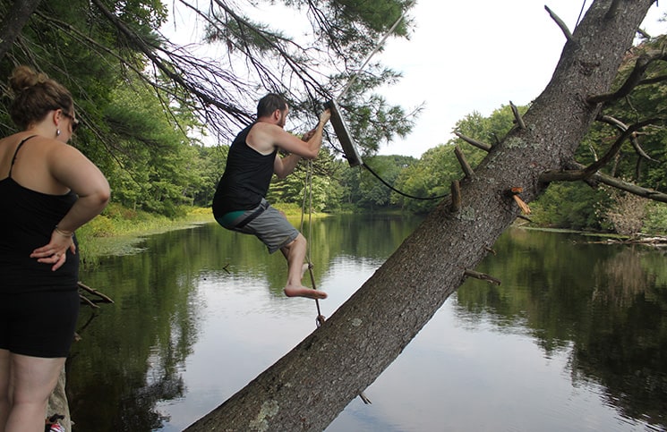
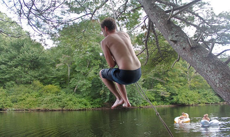
Above and at top: swimming and swinging on the Lamprey River.
The Lamprey is notable for its history and feeding into nearby Packer’s Falls in Durham. It’s also great for swimming, kayaking, canoeing, and fishing. With a canopy of trees bowing over the river, nearby residents have tied up public rope swings for swimmers to enjoy. Though some are available to the public, others are on private property, so double-check if it seems questionable. Some public swings are hidden, their locations known mostly by locals and accessible only by swimming to them. Make sure you’re able to go the distance before diving in.
How to get there: From Portsmouth, take Route 33 and Route 108 north to the Beech Street exit in Newmarket. Continue from Beech Street on to Salmon Street. Turn right onto Piscassic Street and follow until you reach the boat launching area at the end of the road. Note: parking in nearby lots is for residents only and street parking is limited.
Hebron: Sculpted Rocks
This small gorge was formed more than 12,000 years ago from glacial movement during the Ice Age. The gorge is part of the Cockermouth River, which passes between the rocks carrying silt and sand, smoothing the stones over millennia to create natural waterslides and cavernous climbing areas. This location is listed on the visitor center’s map and there is signage in town, so the area does draw a crowd later in the day.
How to get there: Take exit 23 off I-93 and head west on Route 104 toward Bristol before taking Route 3A to Route 3 around Newfound Lake into the town of Hebron. Head west into Groton and follow Sculpted Rocks Road. Look for parking signs.
Bartlett: Diana’s Baths
Located not far from North Conway, Diana’s Baths cozies up next to Lucy Brook, which is fed by runoff from Big Attitash Mountain. The land was owned by the Lucy family, who built a water wheel-powered sawmill and, later, a dam with a turbine system. A guesthouse was also built on the site in the late 1800s, but the structures were razed in the 1960s. Their foundations and pieces of the dam system can still be seen. The area offers hiking and nearly 75 feet of cascading falls. Though there is onsite parking, visitors are required to purchase a parking pass (the daily pass costs $3 per day and can be used at other U.S. National Forest locations).
How to get there: From Portsmouth, take Route 16 north toward Conway. Turn left onto Washington Street and make a slight left onto West Side Road. Turn left onto Old West Side Road and then make a right onto Cathedral Ledge Road.